

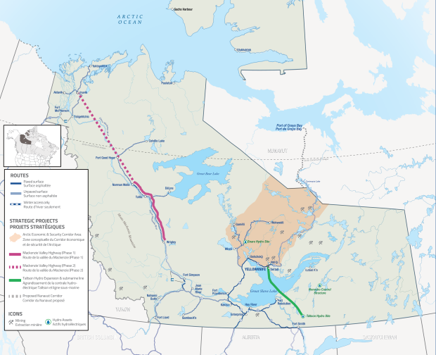
The Mackenzie Valley Highway (MVH) project is a transformative strategic initiative that will establish a critical transportation corridor into Canada’s arctic. This will mitigate the existing impacts of climate change on increasingly isolated communities in the Mackenzie Valley, open the region to mineral exploration and tourism and support Canada’s arctic sovereignty and security.
The current phase of the MVH proposes to replace approximately 320 km of the seasonal Mackenzie Valley Winter Road by extending all-season road access from the end of Highway 1 at Wrigley, to Tulita and Norman Wells. Phase 2 would extend the highway from Norman Wells to Inuvik.
Learn more about the proposed location for the road by visiting the Proposed Mackenzie Valley Highway Project Interactive Map.
Anticipated Benefits
-
Improved inter-community mobility, accessibility, and stabilization of the cost of living.
-
Enhanced Arctic sovereignty and security through improved safety, reliability, and resiliency of the NWT transportation system.
-
Stimulation of direct economic development through project construction, operation, and maintenance.
-
Support for economic growth and diversification in resource development, remediation, and tourism sectors.
-
Establishment of a reliable transportation corridor in the face of a changing climate.
Current Status
- The MVH Project has been referred to Canada's Major Projects Office.
- The MVH Project is currently undergoing environmental assessment (EA) before the Mackenzie Valley Environmental Impact Review Board.
- Funding to advance planning studies and complete the EA for Phase 1 was secured in 2018 through Transport Canada’s National Trade Corridors Fund.
- Environmental and engineering studies, Indigenous Knowledge studies, socio-economic assessments, and community engagement are ongoing.
- Since 2018, 20.7 km of road has been constructed through community capacity-building projects.
- The GNWT has signed a Memorandum of Understanding with Sahtú Secretariat Incorporated and continues to work with Indigenous governments and organizations to advance the project.
Next Steps
- 2026: Continue work with the Major Projects Office to advance nation-building projects faster and more responsibly to help connect our economy, diversify our industries and trade, and create high-paying careers for generations to come.
- 2026: Community information meetings in Norman Wells, Délı̨nę, Tulita, Fort Good Hope, Colville Lake, and Fort Simpson
- 2026: EA, Indigenous engagement, Dehcho routing development, and environmental and engineering work.
- 2026/2027: Report of EA and responsible Minister’s decision.
- 2027/2028: Regulatory permitting and authorizations to support construction.
- Ongoing: Work to finalize project design and identify and evaluate construction funding opportunities.
- A final construction decision, anticipated in 2028 is contingent upon the EA, regulatory permitting and funding.
Project Activities
The Project entails a new two-lane gravel road between Wrigley and Prohibition Creek (located 28 km southeast of Norman Wells). The Project will connect to existing bridges along the Mackenzie Valley Winter Road alignment.
- Widening of the existing cleared Mackenzie Valley Winter Road (MVWR) right-of-way (ROW) and clearing of intermittent sections of new ROW
- Construction of approximately 281 km of new all-season gravel highway embankment (102 km in the Dehcho Region, 179 km in the Sahtu Region) and intermittent pullouts
- Construction of approximately 85 culverts as watercourse crossing structures
- Construction and operation of approximately six temporary borrow sources and quarries and associated all-season access roads
- Construction and operation of approximately nine permanent borrow sources and quarries and associated all-season access roads
- Water withdrawal and water use for road construction and maintenance
- Construction and operation of temporary support infrastructure and workspaces, including camps, maintenance yards, laydown and staging areas, and fuel storage areas
- Staging, supply and resupply of equipment, materials, fuel, and personnel
- Construction and operation of permanent maintenance yards
- Closure and reclamation of temporary borrow sources, quarries, and workspaces
- Demobilization of equipment and materials
- Closure and reclamation of portions of the MVWR ROW not used for the Project
- Operations and maintenance activities including snow clearing, grading, dust control, and bridge and culvert maintenance
- Use of the highway by the public
Construction Schedule
The Project is expected to be built in 3 segments and anticipated to take 10 years to construct over approximately 20 years, subject to construction funding and regulatory approvals.
- Wrigley to the Dehcho–Sahtu border (102 km)
- Tulita south to the Dehcho–Sahtu border (134 km)
- Tulita north to the Prohibition Creek Access Road (45 km)
Funding
In June 2018, the Government of Canada and the Government of the Northwest Territories (GNWT) announced $140 million funding for the environmental assessment and planning studies for the Mackenzie Valley Highway, as well as the planning and construction of the Great Bear River Bridge and the Mount Gaudet Access Road. Additional funding was obtained through the Infrastructure Canada’s Investing in Canada Plan (ICIP) for the construction of the Prohibition Creek Access Road – Phase 1.
Funding is yet to be secured for the construction of the Mackenzie Valley Highway. The GNWT continues to identify and evaluate funding opportunities.
History
The vision of an all-season highway through the Mackenzie Valley to the Arctic Coast has been a strategic priority for Canada since 1958, under the “Roads to Resources” program. This vision is restated in several GNWT strategic documents, including Investing in Roads for People and the Economy: A Highway Strategy for the Northwest Territories; funding proposals, Corridors for Canada and Corridors for Canada II; and in the 2015 Northwest Territories Transportation Strategy.
Timeline
1972 – Construction started in Fort Simpson
1977 – Construction was halted approx. 18km south of Wrigley and a 10-year moratorium on oil and gas development was implemented.
1994 – Completion of the remaining 18 km of the Mackenzie Highway to Wrigley.
2010 – MOU signed with GNWT and Gwich’in Tribal Council (representing the Tulita Land Corporation, Norman Wells Land Corporation, Fort Norman Metis Land Corporation, Tulita Dene Band, K’ahsho Got’ine Development Foundation, and the Pehdzéh Kį First Nation) to support further highway planning and permitting.
2013 – GNWT submitted the Environmental Assessment to the Mackenzie Valley Environmental Impact Review Board
2014 – project was revised to focus on the segment from Wrigley to Norman Wells rather than the entire 818 km to the Dempster Highway.
2018 – The Government of Canada and the GNWT announce $140 million in funding for environmental assessment and planning studies.
2019 to Present – The GNWT conducted extensive studies and engagement to develop the Developer’s Assessment Report (DAR) and address concerns about the Mount Gaudet Access Road by incorporating it into the MVH project. The DAR was submitted in 2023, reinitiating the environmental assessment, which is ongoing. The GNWT continues to collaborate with partners to advance the Project.